Dareen Hills Park | Jubail, Saudi Arabia

As part of Saudi Arabia’s sustainability goals for 2030 and beyond, the city of Jubail has implemented a new blue-green system redistributing large quantities of Treated Sewerage Effluence (TSE) to supply irrigation for a new green network of parks and streetscapes.
An urban scaled collection, treatment, and distribution system evolved whereby as the city grows over time, so will the availability of the TSE water for the strategic purpose of irrigating public parks, improving street conditions, fostering pedestrian beach access, restoring vibrant and ecologically diverse shorelines, and providing public amenities.

Existing Conditions
Dareen Hills Park is a 70-hectare park composed of three distinct layers: a linear neighborhood park, a central sculpture park in the form of a series of large earth forms, and an ecological island, which will serve as context for the reestablishment of local ecologies providing significant recreational amenities.
Role: Landworks Studio Inc. completed concept design and schematic design. Other design phases completed locally.
Client: The Royal Commission for Jubail and Yanbu
Architects/Planners: CBT Architects
Engineers: Fahd Alireza Engineering Consultants (FAEC)
Photography: Yaqob Alabdulhadi, Usman Palasseri
Status: Construction Ongoing
Jubail Water Diagram for 2014
Jubail Water Diagram for 2030
Morphing the Ground Plane
Dareen Hills Park
As an expansion of the existing urban fabric and as a coastal restoration project, the design team explored several organizational strategies geared toward the establishment of conditions and micro-climates which would bring together cultural and ecological activities and systems. Ultimately, it was determined that the notion of layering most efficiently responded to both the growing city and to notions of coastal resiliency and sea level rise.
Neighborhood Park
The first layer of Dareen Hills, directly adjacent to a newly constructed housing development, is the 15-hectare Neighborhood Park. Pergolas and dense plantings of deciduous trees offer relief from the sun while large expanses of lawn and splash fountains offer opportunities for family gathering and play. Recreational pockets of playgrounds and courts are sprinkled throughout.
Hills and Art Park
The central layer is composed of a sequence of large landforms designed to add topographical complexity to the site as well as contain water tanks that house the treated wastewater which provide irrigation for the entire park. The mounds terminate in a waterfront promenade that allows visitors direct access, via terraces and ramps, to the fluctuating tides of the Gulf. Plantings and pergolas offer respite from the sun while the mounds and benches offer seating for evening gatherings and events.
Inspired by the region’s historic pearling industry
Ecological Corniche
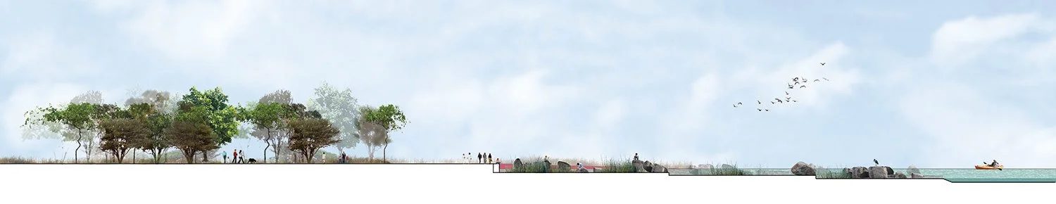
The final layer, the Ecological Corniche, spans 24 hectares and features an island dune landscape adorned with native grasses, salt-tolerant shrubs, and mangroves. This area will feature beaches, nature trails, picnic spots, and designated tent sites for campfires, offering a serene retreat from the city while attracting both visitors and migratory birds. The corniche also supports nearby barrier islands, Jana Island and Juraid Island, which are vital nesting grounds for green sea turtles. These islands are home to coral reefs that sustain a variety of marine life and serve as habitats for significant bird populations.
Early Concept Sketches
Restaurant, Tide Pool, and Garden
Exploration Pods
Pedestrian Bridge & Fishing Pier
Beach Pier
Promenade at Bridge
Kayak Landing & Rock Climbing Garden
Planting Plans

click below for slide show of additional images